Summary
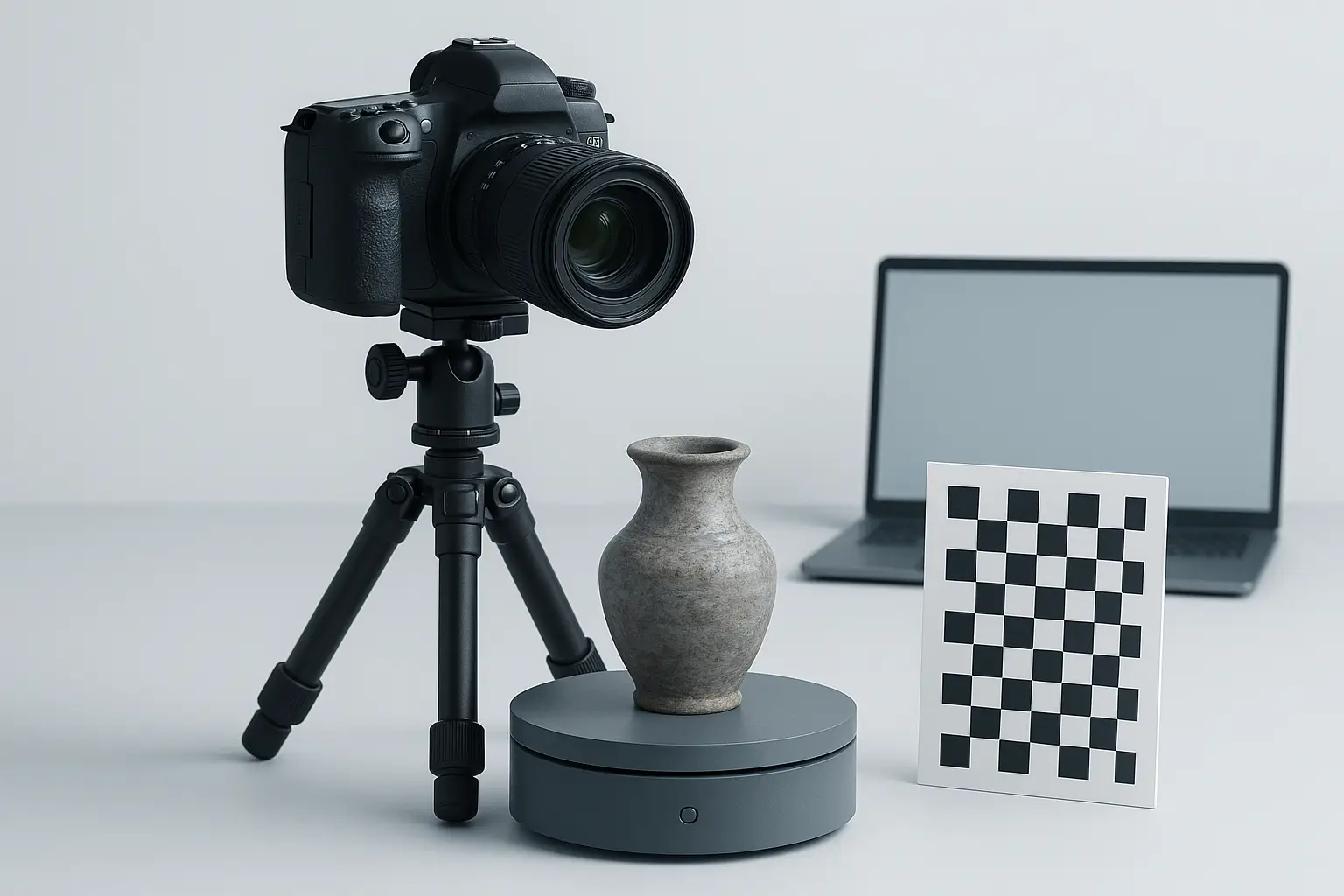
Photogrammetry is the science of obtaining reliable 3D information from photographs, enabling 3D from photos using specialized camera techniques and software. The two primary types — close-range and aerial photogrammetry — allow experts to scan using camera setups for various domains, from architecture to topographic mapping. Modern photogrammetry software has broadened accessibility, offering detailed 3D reconstruction from images for industry and research alike. [4]
Historical Background
Aimé Laussedat, regarded as the father of photogrammetry, pioneered terrestrial mapping using photographic images in France around 1851. His work laid the foundations for camera-based 3D capture and photogrammetric measurement. [2]
The term “photogrammetry” was introduced by Albrecht Meydenbauer in Germany in 1867, who later established a photogrammetric institution in 1885, institutionalizing the science for architectural and topographical documentation. Meanwhile, in the 1880s and 1890s, Édouard-Gaston Deville’s advancements in Canada showcased the efficacy of these methods by mapping approximately 83,678 square kilometres of land using phototopography. This widespread adoption highlighted photogrammetry’s practical potential for large-scale surveying and inspired international usage in other countries. [1][3]
Principles of Photogrammetry
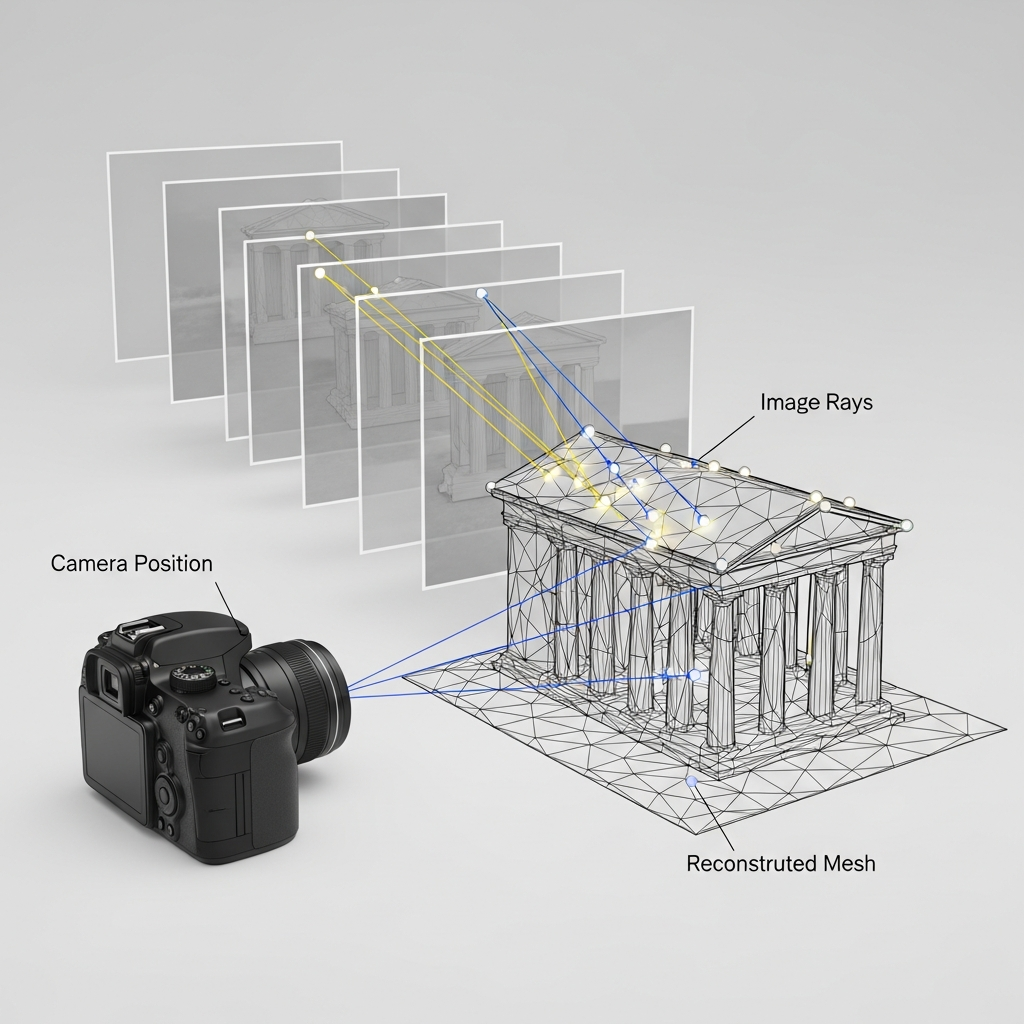
At its core, photogrammetry uses the geometric principles of perspective and projective geometry to extract precise 3D measurements from 2D photographs. Central methodologies include stereophotogrammetry — where overlapping images from slightly different angles are combined to triangulate accurate spatial coordinates. Highly sophisticated algorithms, often referred to as bundle adjustment, are used to refine the 3D reconstruction process, minimizing error and achieving reliable outputs. This scientific process is foundational for creating detailed digital models from image datasets, driving a diverse spectrum of real-world applications. [4][5]
Types of Photogrammetry
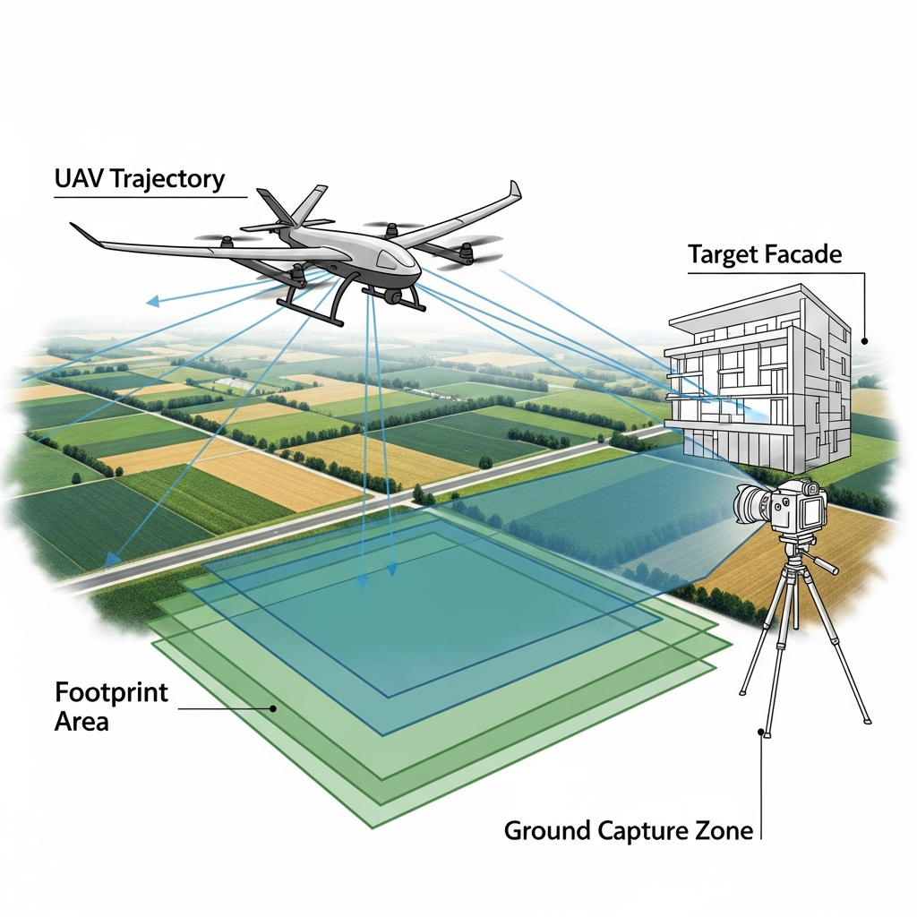
Close-range photogrammetry investigates objects or scenes from short distances for precise detail, while aerial photogrammetry captures large areas from above, typically using drones or aircraft to scan using camera systems. This division reflects differences in technical approach and application.
Close-range photogrammetry is commonly used in engineering, architecture, and archaeology, relying on handheld or tripod-mounted cameras for dense, accurate 3D models. Conversely, aerial photogrammetry utilizes airplanes or unmanned aerial vehicles (UAVs) for extensive area capture, essential in topographical mapping and land surveying. Recent trends show widespread photogrammetry software adoption for both modes, automating 3D reconstruction from images. Application domains now span mapping, filmmaking, and essential documentation for disaster analysis and heritage conservation. [6]
Comparison Table: Close-Range vs. Aerial Photogrammetry
| Aspect | Close-Range | Aerial |
|---|---|---|
| Typical Platform | Handheld/tripod | Drone, airplane |
| Typical Range | 0.5 – 30 meters | 50 – 3,000 meters |
| Main Applications | Architecture, forensics, archaeology | Topographic mapping, agriculture |
| Image Overlap | High (for accuracy) | High (for coverage continuity) |
| Camera Type | DSLR, smartphone | Metric camera, UAV camera |
Performance Considerations
The accuracy of photogrammetric measurement depends on several factors: camera resolution, lens quality, spatial overlap between images, camera calibration, and the physical layout of the object or terrain being scanned. Image quality and precise control over camera positions greatly influence achievable detail and reliability. While high-accuracy systems can deliver millimeter-level results in controlled settings, no reliable figure was found for typical real-world accuracy across all workflows — existing results vary significantly by application, hardware, and environment. This underscores the importance of rigorous quality assurance and attention to acquisition methodology when seeking optimal detail from scan using camera photogrammetry.
Applications
Photogrammetry is applied extensively across a range of fields. Prominent application domains include:
- Topographic mapping
- Architectural documentation
- Filmmaking and visual effects
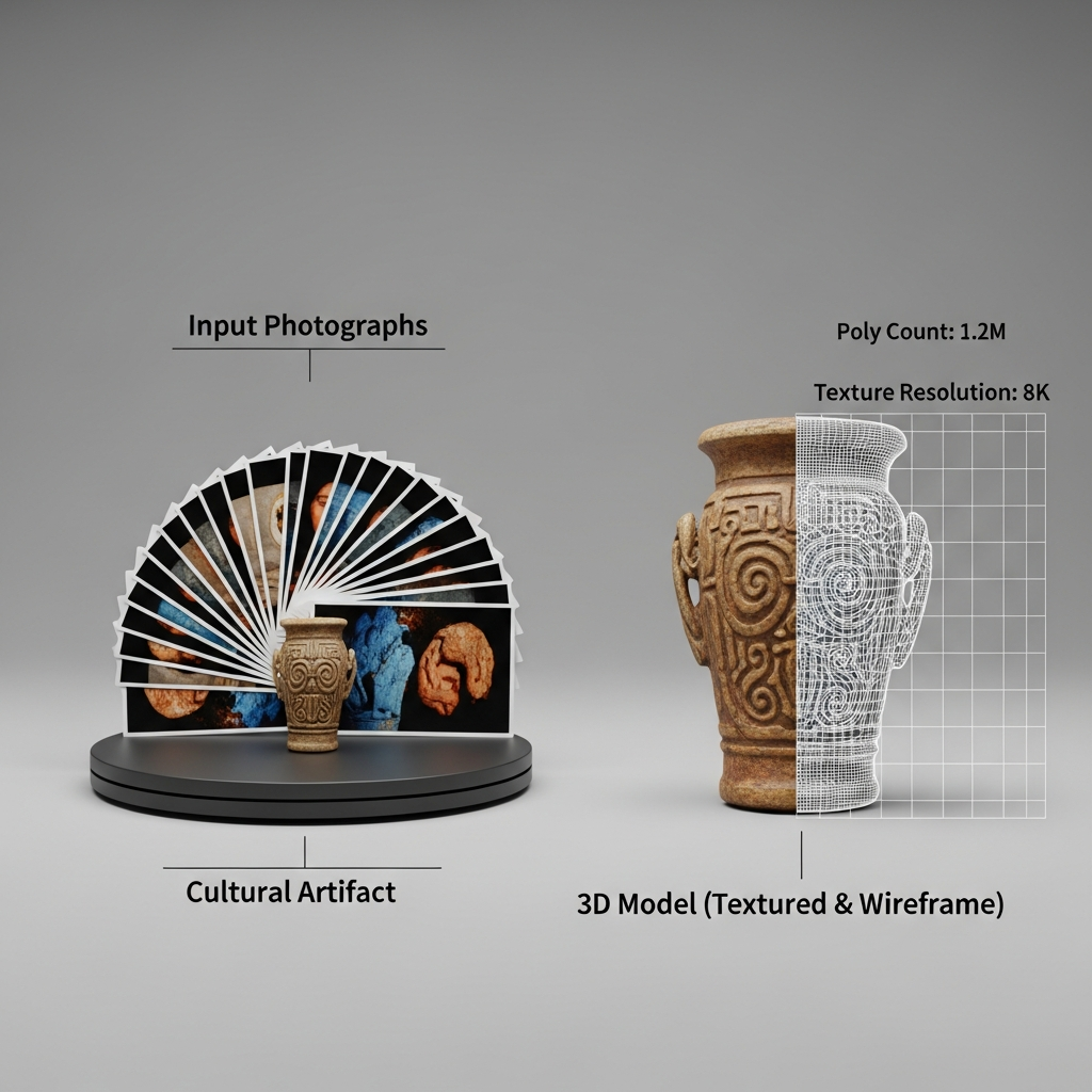
- Archaeology and cultural heritage
- Collision and accident analysis
- Subsea and underwater inspection
These diverse uses leverage the flexibility of 3D from photos and the increasing sophistication of modern camera technologies. [6]
In addition, 3D from photos allows realistic asset capture for digital environments in video games and digital twins in cultural heritage, using photogrammetry software to automate the process of 3D reconstruction from images. Such workflows dramatically reduce manual modeling overhead and preserve fine detail from real-world objects and locations. [4]
Research Updates
Contemporary research explores advanced artificial intelligence (AI) integration, drone-based capture for rapid data acquisition, and high-precision digital terrain modeling. These trends position photogrammetry software at the forefront of scalable, efficient 3D reconstruction, though standardized metrics for such systems are still emerging. [7]
Q&A (FAQ)
1. What is 3D from photos and how does photogrammetry software implement it?
3D from photos refers to extracting three-dimensional information from two-dimensional images, a task fulfilled by photogrammetry software. The software aligns multiple overlapping photographs, determines camera positions, and reconstructs 3D geometry through mathematical processes like triangulation and bundle adjustment. [4]
2. How accurate is scan using camera photogrammetry?
Accuracy depends on image quality, camera resolution, lens calibration, and amount of image overlap. No reliable universal figure exists for typical accuracy due to workflow variations and environmental factors. Accuracy is highest in controlled conditions with high-resolution cameras and careful technique. [6]
3. What are the differences between close-range photogrammetry and aerial photogrammetry?
Close-range photogrammetry uses cameras from short distances (often handheld or tripod), best for small/medium objects or sites; aerial photogrammetry employs platforms like drones or aircraft to survey large areas from above. Their applications, range, platform, and operational scope differ significantly.
4. Which photogrammetry software are widely used for 3D from photos?
Several platforms are recognized for robust photogrammetric measurement and 3D reconstruction from images, including:
- 3DF Zephyr
- RealityCapture
- ContextCapture
- Pix4Dmapper [8]
5. How did Aimé Laussedat and Meydenbauer contribute to the development of photogrammetric measurement?
Aimé Laussedat initiated terrestrial photogrammetry using images for mapping in the early 1850s, earning recognition as the field’s founder. Albrecht Meydenbauer coined “photogrammetry” in 1867, institutionalized its practice, and set technical standards in Germany, promoting international adoption. [1][2]
6. What future research updates are emerging in photogrammetry software using camera data?
Significant advancements involve integrating AI for processing automation, leveraging drone imagery for efficient surveying, and improving digital terrain modeling. These drive improvements in data quality, processing speed, and scalability but are still evolving in terms of measurable outcome standards. [7]
Sources
- Photogrammetrie – German Wikipedia (term coined by Meydenbauer, 1867)
- Photogrammetry — Britannica (Aimé Laussedat, 1851)
- Édouard-Gaston Deville — Wikipedia (83,678 km² survey)
- Photogrammetry — Wikipedia (definitions, methods, applications)
- Photogrammetry — Wikipedia (technical principles)
- Photogrammetry — Wikipedia (applications fields)
- Photogrammetry and AI — Built In
- Photogrammetry — Wikiversity (software example list)